Watch the video below for an overview of this plan, and view further details below. You can also view and comment using our interactive map tool.
Key Plan Elements
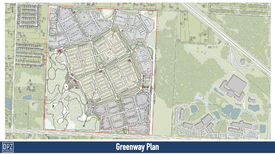
This is one of 2 hybrid plans with a more limited mix of uses than the marketability plan suggested could be accommodated on site.
- Organization – This plan is defined by a grid of greenways. The town center is located along 9-mile Rd with a mix of offices, shops, restaurants and some multi-family buildings. An eastern industrial commerce district is suggested with entrances of 9-mile Rd. It wraps around the north and NW corner along Frank Reeder which anticipates the 1-10 interchange at Beulah Rd. A central low-density residential neighborhood is proposed for the center, with 4 quadrants defined by large attached greens and a street of live-work units. A north-south main street spine and broad greenway ring road connect all 4.
- Marketability – The plan provides for a healthy mix of all market uses that are likely to be desired in this region and a flexible framework to make market adjustments as the project is built incrementally.
- Walkability – Each neighborhood is designed to have a quarter mile radius (5 min. walk) from center to edge. Amenities and Civic facilities are distributed throughout site, with plentiful array of green space. The broad greenway features shared walking trail for walkers, joggers and equestrian riders down the center.
- Transportation – Neighborhood structure provides centrally-located pick-up locations within 5 minute walks of each address for both regional bus transit or local shuttles.
- Environment – The Greenway system connects directly with the southwestern park. New stormwater ponds create a focal point for the retail and restaurant at the town center edges, and help manage the stormwater drainage needs of the site. The trail system, for both people and horses, continues into the large park in the southwest that incorporates the wetlands and existing tree stands with passive and active recreation, as well as civic uses and community farming.
- Edges – Bands of green spaceframe the entire site and are integrated into the Greenway system of this community. Roadways into the privately owned western properties are avoided and views screened, but future connections are not precluded. A connection to Navy Federal is anticipated on the east side.
- Innovation – A modular block structure offer incremental phasing and future flexibility. It is envisioned that this central neighborhood could remain open space initially, and then be phased incrementally as the demand arises.
Plan and Plan Details