Watch the video below for an overview of this plan, and view further details below. You can also view and comment using our interactive map tool.
Key Plan Elements
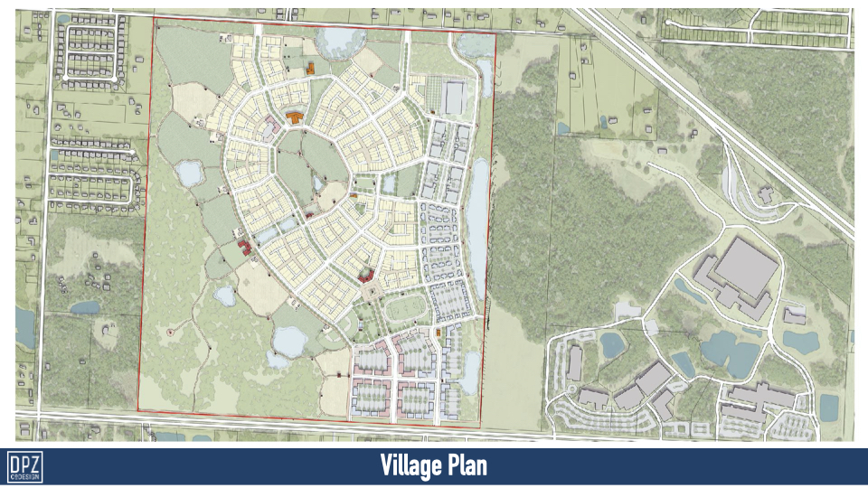
This is one of 2 hybrid plans, and is focused around Beulah’s agrarian and rural roots. It is the least developed of the 4 plans
- Organization – A commerce park is embedded along the eastern end of the site. A village center with shops, housing and office uses along pedestrian-oriented streets is located on the south end of the plan, along 9-mile Road, while a centralized agricultural or common green space serves as a key community feature, surrounded by quiet residential neighborhoods and amenities such as a winery and restaurant. The village boundaries transition into agriculture and then nature.
- Marketability – While potentially not at full market capacity for commerce or housing, this plan provides for a unique and active agrarian community experience. It is the plan with the least amount of residential proposed.
- Walkability – Mid-block shared streets, multi-use paths, destinations, scenic agrarian vistas and unique pedestrian experiences allow for useful and interesting daily walks in this plan.
- In terms of transportation – This plan aims at reducing the street network load and provides a diverse variety of options including an interconnected trail system accessible for equestrian, biking, walking and other active recreation and transportation uses.
- Environment – The wetlands and wooded areas remain intact in this plan with substantial land preserved for open space, agriculture and minimal impact recreational uses.
- Natural elements are also integrated within the village and open green spaces serve as stormwater retention ponds when needed.
- Edges – Except for the village center edge along 9 Mile road to the south, the site retains natural edges throughout, composed of wooded areas, agriculture, greenways and paths.
- Innovation – This plan takes on a traditional village concept where the village boundary is defined by farmstead and agrarian parcels while providing a flexible block structure within for a variety of uses.
Plan and Plan Details